¡Vikidia te necesita! Actualmente tenemos 6623 artículos. ¡Anímate! |
Archivo:Argentina (orthographic projection).svg
Ir a la navegación
Ir a la búsqueda


Tamaño de esta previsualización PNG del archivo SVG: 541 × 541 píxeles. Otras resoluciones: 240 × 240 píxeles · 480 × 480 píxeles · 768 × 768 píxeles · 1024 × 1024 píxeles · 2048 × 2048 píxeles.
Archivo original (archivo SVG, nominalmente 541 × 541 píxeles, tamaño de archivo: 376 kB)
| Descripción |
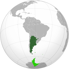
Deutsch: Geographische Lage Argentiniens in orthographischer Projektion.
souveränes Gebiet
beanspruchte Gebiete English: Location of Argentina in orthographic projection.
Sovereign territory.
Claimed territories. Español: Ubicación geográfica de la República Argentina en proyección ortográfica.
Territorio soberano.
Territorios en reclamo. Nederlands: Geografische ligging van Argentinië in orthografische projectie.
Soeverein gebied
Opgeëiste gebieden |
||
| Fecha | |||
| Fuente | Own work, based on the Image:Brazil (orthographic projection).svg, created by the Wikimedia Commons user Ssolbergj, under a Creative Commons Licence. | ||
| Autor | Dexxter | ||
| Permiso (Reutilización de este archivo) |
Yo, el titular de los derechos de autor de esta obra, la publico en los términos de la siguiente licencia: Este archivo se encuentra bajo la licencia Creative Commons Atribución 3.0 Unported.
|
||
| Otras versiones |
Obras derivadas de ésta: Chile orthographic projection.png .svg)
|
||
| SVG desarrollo |
.svg)
.svg)
.svg)
.svg)
.svg)
.svg)
.svg)
.svg)
.svg)
.svg)
.svg)
.svg)
.svg)
.svg)
.svg)
.svg)
.svg)
.svg)
.svg)
.svg)
.svg)
.svg)
.svg)
.svg)
.svg)
.svg)
.svg)
.svg)
.svg)
.svg)
.svg)
.svg)
.svg)
.svg)
.svg)
.svg)
.svg)
.svg)
.svg)
.svg)
.svg)
.svg)
.svg)
.svg)
.svg)
.svg)
.svg)
.svg)
.svg)
.svg)
.svg)
.svg)
.svg)
.svg)
.svg)
.svg)
.svg)
.svg)
.svg)
.svg)
.svg)
.svg)
.svg)
.svg)
.svg)
.svg)
.svg)
.svg)
.svg)
.svg)
.svg)
.svg)
.svg)

.svg)

.svg)

.svg)
.svg)
.svg)
.svg)
.svg)
.svg)
.svg)


.svg)
.svg)
.svg)
.svg)
.svg)
.svg)
.svg)

.svg)
.svg)
.svg)
.svg)
.svg)
.svg)
.svg)
.svg)
.svg)

.svg)
.svg)
.svg)
.svg)
.svg)
.svg)
.svg)
_without_national_boundaries.svg)
.svg)
.svg)
.svg)
.svg)
.svg)
.svg)

.svg)
.svg)
.png)
.svg)
.svg)
.svg)
.svg)

.svg)
.svg)
.svg)
.svg)
.svg)
.svg)
.svg)
.svg)
.svg)
.svg)
.svg)

.svg)
.svg)
.svg)
.svg)
.svg)
.svg)
.svg)
.svg)
.svg)

.svg)
.svg)

.svg)
.svg)
.svg)
.svg)
.svg)
.svg)
.svg)
.svg)
.svg)
.svg)
.svg)
.svg)
.svg)
.svg)
.svg)
.svg)
.svg)
.svg)
.svg)
.svg)
.svg)
.svg)
.svg)
.svg)
.svg)
.svg)
.svg)
_-_Crimea_disputed.svg)
.svg)
.svg)
.svg)
.svg)
.svg)
.svg)
.svg)
.svg)
.svg)
.svg)
.svg)
_political.svg)
.svg)
.svg)
.svg)
.svg)
_-_Crimea_disputed_-_no_borders.svg)
.svg)
.svg)
.svg)
.svg)
.svg)
.svg)
.svg)
.svg)
.svg)
.svg)
.svg)

.svg)
.svg)
.svg)

.png)
.svg)
.svg)
.svg)
.svg)
.svg)
.svg)
.svg)
.svg)
.svg)
.svg)
.svg)
.svg)
.svg)
.svg)
.svg)
.svg)
.svg)
.svg)
.svg)
.svg)
.svg)
.svg)
.svg)
.svg)
.svg)
.svg)
.svg)
.svg)
.svg)
.svg)
.svg)
.svg)
.svg)
.svg)
.png)
.svg)
.svg)
.svg)
_(orthographic_projection).png)
.svg)
.svg)
.svg)
Historial del archivo
Pulsa sobre una fecha/hora para ver el archivo en ese momento.
| Fecha y hora | Miniatura | Dimensiones | Usuario | Comentario | |
|---|---|---|---|---|---|
| actual | 00:28 26 jun 2014 | | 541 × 541 (376 kB) | wikimediacommons>Chipmunkdavis | Reverted to version as of 23:59, 15 November 2009 Re-adding the Antarctic claims. Argentina has gone as far as to put people in Antarctica. Claims are generally included on these maps. |
Usos del archivo
La siguiente página usa este archivo:
.svg)